Identify continents and oceans
I can identify the 7 continents and 5 oceans on a world map.


8,000 schools use Gynzy
92,000 teachers use Gynzy
1,600,000 students use Gynzy
General
Explore the world with this lesson about the continents and oceans! The lesson includes some fun facts about each of the continents and oceans and also includes songs to help students remember the different names.
Learning Objective
Students will be able to name and locate the continents and oceans on a map.
Introduction
First, have students discuss what they know about globes. Explain what a continent is and that there are 7 continents on Earth. Tell students that they can use the phrase “Never Ever Smile At An Angry Alligator” to remember the first letters of each of the continents. There is also a link to a song/video on YouTube students can listen to. Play the video and have students sing along! Next, explain what oceans are and that there are 5 oceans. Students can say “Penguins Are Interesting And Smart” to remember the first letters of the oceans. Again, play the video and have students sing along.
Instruction
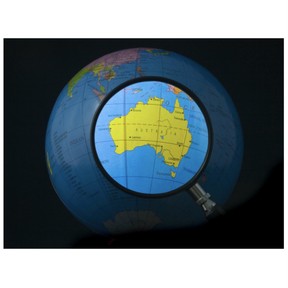
Introduce Edward the explorer who will act as a guide throughout the lesson and take students on a journey around the world. First teach students about North America and show it on the map. Then head to South America, home of the Amazon Rainforest. Share some animals that live in this continent! After this, head over to Europe where you can find the Eiffel Tower. Students drag the magnifying glass to the map to locate the different countries. From here, move on to Asia and share some fun facts. For example, the world’s tallest mountain is found in Asia! Next, show Africa on the map and share some of the large mammals found here. After Africa, go to Australia, the island continent, also known as “The Land Down Under.” Finally, explore Antarctica. Next, have students drag the images to the correct ocean. Test students’ knowledge by having them name the continents on the map. Remove the covers to check.
Quiz
Check student understanding with ten multiple-choice questions. They will also look at a map and identify the different continents and oceans.
Closing
Students will create a world map on a paper plate. They should label the continents and oceans.
Instruction materials
Students will need paper plates and markers, crayons, or colored pencils for the final activity.
The online teaching platform for interactive whiteboards and displays in schools
Save time building lessons
Manage the classroom more efficiently
Increase student engagement
Discover more!

About Gynzy
Gynzy is an online teaching platform for interactive whiteboards and displays in schools.
With a focus on elementary education, Gynzy’s Whiteboard, digital tools, and activities make it easy for teachers to save time building lessons, increase student engagement, and make classroom management more efficient.